The development of radiophysical (radar, optical) methods and facilities for remote diagnostics of dynamic processes in the upper ocean is organically related to the development of physical models for such processes. This trend includes two complementary problems. The first one is to study physical mechanisms of imaging the processes that occur in the near-surface layer of the ocean and on its surface for determining the diagnostic features of deep-water processes for remote observation systems. The second one is to develop and study the inherent remote diagnostics methods, including radar and optical ones, and their efficient application in experimental hydrophysical investigations.
Diagnostics of films on the sea surface.
Study of the physical mechanisms of the wind-wave field variability under the action of films of surface active substances (SAS) and the development of remote-sensing methods for diagnostics of the films, based on this study, are of great applied relevance from the viewpoint of ecological monitoring of sea areas and inland waters. Numerous field investigations of sea film characteristics using radar and optical facilities, including subsatellite experiments in collaboration with the European and German Space Agencies, were carried out at the IAP RAS under the leadership of S. A. Ermakov. The viscous-elastic properties of oil films were described for the first time at the IAP RAS by employing the results of numerical simulation and laboratory experiment (S. A. Ermakov and I. A. Sergievskaya). The obtained results are of great interest for the elaboration of selective methods for remote monitoring, enabling one not only to record the SAS film occurrence on the sea area surface, but also identify their origin.
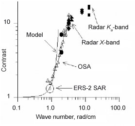 |
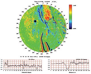
The degree of short wind wave quenching (contrast) measured by various remote facilities in a subsatellite experiment from an oceanographic platform in the Black Sea
|
 |
|
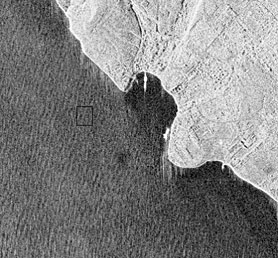
Image segment of an oil patch on the sea surface, obtained with a synthesized aperture radar (SAR)
from the Envisat satellite (left) and an oil spill image made with the IAP RAS coastal radar (right)
|
Radar diagnostics of eutrophication zones in water basins.
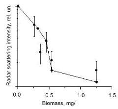
Intense algal bloom of the phytoplankton, primarily, blue-green algae (cyanobacteria), is a significant threat for the ecology of shallow seas and shelf areas of the ocean, as well as of inland waters, because it results in reduced water clarity, decreased concentration of dissolved oxygen, a strongly increased level of the toxic content in water, more intense silting processes in water basins, etc. The possibilities of remote-sensing systems, including satellite ones, open wide prospects for diagnostics of high bio-productivity areas and their monitoring. Satellite scanners of the optical and IR bands are widely applied now. However, the use of optical systems is essentially limited by the day time and cloudiness state; thus, the efficiency upgrading of ecological monitoring of water basins is associated with the use of microwave radars.
The team headed by S. A. Ermakov has recently studied the physical mechanisms of the phytoplankton effect on small-scale wind waves and physically substantiated the application of radars for diagnostics of eutrophication areas.
|
|
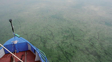
Photograph of the water surface under the conditions
of intense algal bloom of the phytoplankton
in the Gorky Reservoir
|
Measured (•) and theoretically calculated (♦) intensities of the Х-band radar signal as function
of phytoplankton concentration
|
Traces of surface vessels.
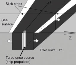
The problem of studying the surface vessel characteristics by means of remote sensing is of particular interest for both the problems of maritime navigation and ecological monitoring, primarily, the detection of the vessels that pollute the sea surface. Experimental research was carried out at the IAP RAS, a model for the expansion of the surface vessel trace with distance was proposed, and the main peculiarities of trace manifestations on a rough sea surface were revealed (S. A. Ermakov and I. A. Kapustin).
Radar sensing of the sea surface.
Modern methods of radar ocean diagnostics from aircraft and satellite carriers have evident advantages compared with contact methods, as they enable one to obtain information from large water areas. The development of systems and methods for radar sensing of the sea surface provides a marked increase in informativity and operational efficiency of obtained data on retrieved characteristics of both the surface itself and the near-surface physical processes. Therefore, of particular importance is the development of methods for forming and processing of radio images of a rough sea surface using airborne synthetic aperture radars (SAR images) that allow monitoring over vast water areas (M. B. Kanevsky).
As part of the Federal Space Program, the IAP RAS actively participates in scientific support of the development and launch of the first Russian scatterometer (V. Yu. Karaev et al.) that will be installed on the satellites "Meteor-3" and "Meteor-MP". The opportunities of the developed scatterometer concept greatly exceed those of the counterparts and will permit one to significantly upgrade the operational monitoring of the World Ocean and land surface.
 |
|
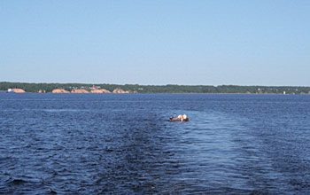
Manifestations of a surface vessel trace on the sea surface (left) and the physical model of the trace. The IAP RAS experiments in the Black Sea
|
Radiophysical hardware complex for remote sensing of the sea surface.
Original devices were designed at the IAP RAS, which were frequently used for remote sensing of the sea surface both from research vessels and oceanographic platforms:
- radars with operating wavelengths of 8.7 mm and 3.2 cm designed for onboard measurements of the intensity of a radar signal backscattered by small-scale wind waves and of the wind wave velocities (they operate in vertical and horizontal polarizations);
- Doppler radar (the operating wavelength is
3 cm) with a knife-beam antenna pattern designed for nadir observations of the sea surface to retrieve the statistical characteristics of a rough water surface and to determine the propagation direction, the average length, and the height of long waves;prototype of a unit for data receipt and record from a standard shipborne radar, which records radar panoramas of the sea surface;
- optical spectrum analyzers (OSA) of wind waves, operating under the conditions of natural sky light and enabling one to make relative measurements of the wind wave spectrum in a wide wavelength range (from 0.5 cm to 1 m) and of the wave propagation velocity;
- optical wave recorders based on photodetector arrays for spatio-temporal imaging of the sea surface in the "distance — time" coordinates, which can estimate the kinematic characteristics of wind waves and their thin structure.
Standard equipment of the leading world producers is also widely used in the field and laboratory experiments carried out by the IAP RAS.
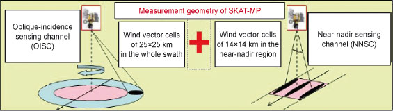 |
The concept of the Russian scatterometer with channels of oblique-incidence and near-nadir sensing
|
|
|
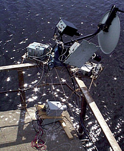
Onboard complex of diagnostic equipment:
radars, optical spectrum analyzers
|
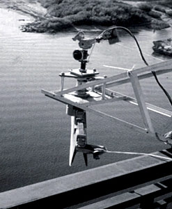
Radar with a knife-beam antenna pattern
|